 Alliance Technical Group’s GMAP service is a breakthrough in how we monitor and manage air quality. GMAP, which stands for Geospatial Measurement of Air Pollutants, is like a high-tech detective for air pollution. It’s a mobile service, meaning our team can travel around, gathering information on various air pollutants. It uses sophisticated technology to analyze this data and create detailed maps showing where these pollutants are most concentrated, helping to pinpoint the sources of pollution.
Understanding Air Quality Challenges
Air pollution is a complex issue. It’s not just about the amount of pollutants in the air, but also about understanding how they move and change over time. Traditional stationary monitoring methods only give us a snapshot of the situation, often missing the bigger picture. Pollution doesn’t stay put; it spreads and changes with the wind, weather, and other factors. GMAP’s ability to move and track pollution in real time gives us a much clearer view of what’s happening with our air quality.
How GMAP Makes a Difference
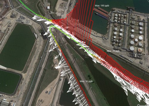
GMAP is essentially a mobile laboratory. Our team is equipped with advanced instruments to measure different types of air pollutants at numerous points across the facility, including along the fenceline and surrounding roadways. These instruments include multiple gas analyzers and highly accurate GPS systems for mapping. This technology allows for real-time, on-site air quality assessments, which are crucial for quick and effective environmental management. Alliance also collects weather data, bringing together gas analyzers, wind data, and GPS to generate maps. Wind direction is essential to this process as it allows our team to backtrack from the observed pollutant concentration to the potential emission source(s).
Picture a petroleum refinery that needs to ensure it’s not exceeding pollution limits. GMAP can be brought in to monitor the air both within and around the facility boundary at any location accessible by vehicles (including the facility fenceline, neighboring communities, etc.), giving instant feedback and helping to pinpoint potential areas of concern relevant to environmental regulatory compliance.
Tech Trends and Advancements
The technology behind GMAP is part of a larger trend towards smarter, more connected environmental monitoring systems. We’re seeing a rise in the use of real-time data analysis, Internet of Things (IoT) devices, and advanced mapping software in environmental science. These tools are making it possible to understand and respond to environmental challenges more quickly and accurately than ever before.
Benefits of GMAP
- Real-time Data and Analysis: The ability to gather and analyze data in real time is a significant advantage. It enables quicker responses to potential environmental hazards and helps in making informed decisions to mitigate risks.
- Advanced Mapping and Analysis: GMAP’s geospatial mapping program enhances the understanding of air pollutant dispersion and source identification, which is crucial for effective air quality management.
- Mobility and Flexibility: Alliance’s GMAP can move across a facility and monitor in real time, a significant advantage compared to stationary monitoring devices. This allows for a full picture of pollutant concentrations across the entire site and is less dependent on wind direction.
- Contribution to Public Health and Environment: By ensuring better compliance with air quality standards and providing accurate data on pollutant levels, GMAP plays a crucial role in protecting public health and the environment.
Potential Results and Impact
By providing real-time, accurate information about air pollution, GMAP can have a significant impact on:
- Improved Public Health: By identifying and addressing pollution sources more quickly, we can reduce exposure to harmful pollutants, leading to healthier communities.
- Increased Corporate Responsibility: Businesses can use GMAP to monitor their own emissions, helping them to operate more sustainably and responsibly.
With its real-time data capabilities, mobile flexibility, and advanced analytical tools, GMAP provides a whole new performance standard for today’s air quality challenges. The Alliance team continues to take significant strides forward in our ability to help our clients safeguard their environments and public health. As industry professionals continue to seek effective and actionable insights, Alliance’s GMAP demonstrates how technology and environmental stewardship can work hand in hand for a healthier, more sustainable future.